Sowing Seeds of Knowledge: Combating Climate Change with Hawaiian Ancestral Agriculture
- Erin Pamplin

- Oct 7, 2023
- 4 min read
Two UC Berkeley researchers created a new geospatial model that can be used to predict ancestral agricultural sites in the Hawaiian archipelago. With this model, they can more accurately estimate how much harvest, biodiversity, and habitat alteration these farming methods produced which can be applied today to help combat food insecurity and climate change.

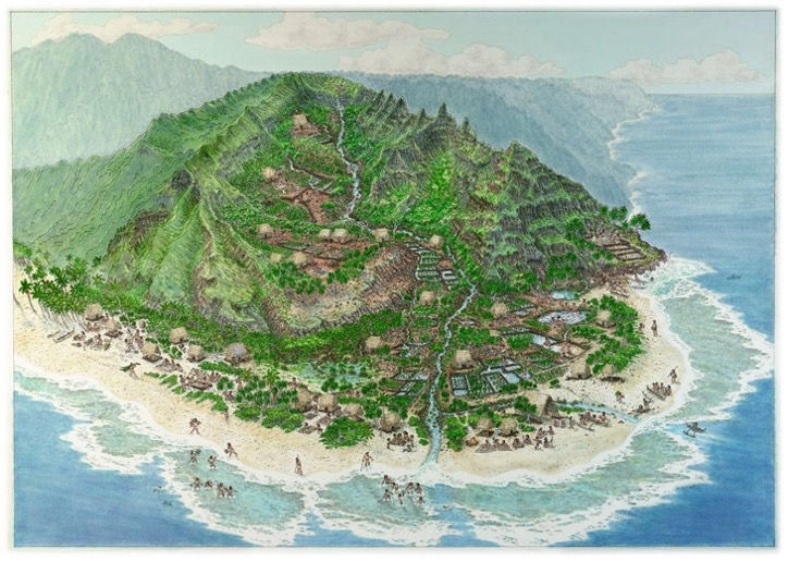
Students harvesting halo plants from a traditional irrigated, terraced pondfield on Oahu (Ka’ala Farm).
Around 1000 CE, Hawai’i was first settled by voyaging Polynesians, travelling North from Tahiti and the Marquesas. Spanning a nearly 800-year period prior to European contact, Hawaiians developed agricultural techniques that optimized the islands’ natural landscapes and supported populations of roughly 400,000 people. They utilized four main systems explained below.
1. Intensive Dryland Systems
Rain dependent field systems
Mainly used to cultivate sweet potato, taro, yam, and sugarcane
Significantly more prone to drought and were labor intensive to maintain
Radiocarbon dating of archaeological sites shows an early establishment of 1400 CE and intensification after roughly 1650 CE
2. Colluvial Slope Cultivation
Rain fed cropping along the mid to lower elevation slopes of valleys where nutrient-rich sediment deposits collect
Archaeological features include dryland terracing and stone mounds
A large variety of root, tuber, and tree crops were cultivated with the main crops being taro, sweet potato, yam, banana, breadfruit, arrowroot, and ti
Significant labor to initially establish, but low maintenance once terracing or mounding was built
Early establishment date of 1200 CE
3. Irrigated Pondfields
Valleys and floodplains that were flooded by diverted streams and springs
Archaeological evidence of the earliest evidenced irrigated pondfields date to roughly 1200 CE
Labor intensive to build the irrigation canals but this method produced significant harvests
Primarily cultivated taro but also sugarcane, banana, and ti
4. Aquaculture
Along shorelines, stone structures were constructed to trap and husband fish, primarily mullet and milkfish
High yields of harvest despite being labor intensive with initial construction
Along the southern coastline of Moloka’i there were at least 73 fishponds
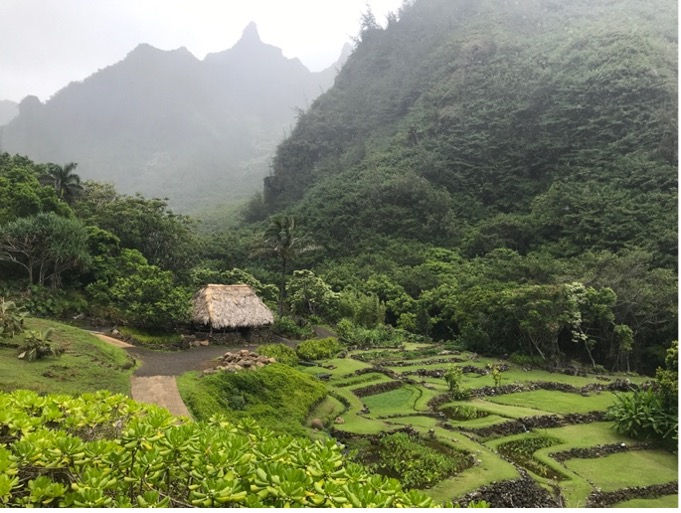
Illustrated recreation and current image of ancestral agricultural structures on Kauai (National Tropical Botanical Garden).
Western colonization has led to an abandonment of traditional agricultural practices only to be replaced with cash crops and a reliance on imported products. This has led to increased rates of poverty, health issues associated with poor diets, and a decrease in biodiversity. Additionally, it has resulted in a loss of much ancestral knowledge around land and resource management and traditional diets.
“When women grow cash crops rather than grow, gather, or wildcraft diverse plants and animals for their own uses and purposes, the results are that they are increasingly detached from the practice of being guardians and custodians of biodiversity, and young people do not learn how be guardians and custodians. Thus knowledge loss occurs both on the home island and on other islands that are part of the networks of islands that make sustainability and resilience possible for each island community” (George 2021).
Developing a Geographic Information System (GIS) model that predicts the size and distribution of various traditional agricultural sites can help with predicting historic island population sizes and densities, the harvest and correlated labor of various agricultural practices, understanding the related sociopolitical dynamics and locating more archaeological agriculture sites. It can aid in testing hypotheses surrounding the introduction, spread, and development of these agricultural systems. It can also help to revive and preserve the climate resilient, ancestral knowledge of land use and agricultural practices.
Previous GIS models excluded colluvial slope agriculture and aquaculture which severely underestimated land use and production. However, two researchers at the University of California, Berkeley, Natalie Kurashima and Patrick Kirch, developed a new model that accounted for these two additional agricultural practices. They applied a focused test of their model on Moloka’i, the fifth largest island of the Hawaiian Islands. The model predictions for various agricultural sites were then compared with known archaeological and ethnohistoric evidence to test its accuracy.
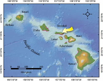
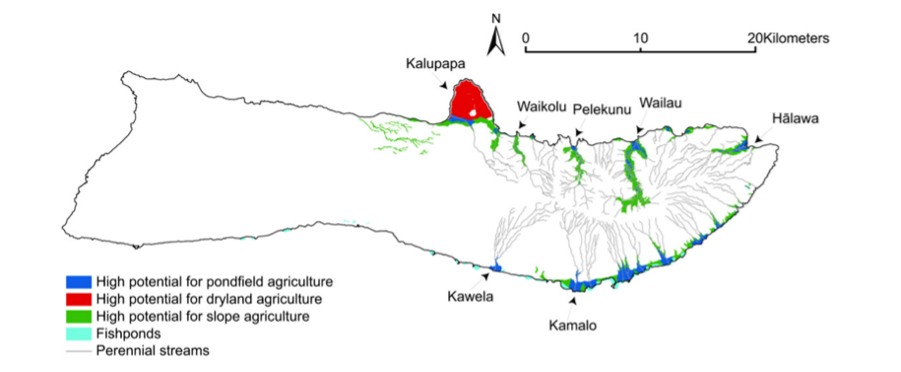
The geographic location of Moloka’i within the Hawaiian archipelago (US Geological Survey 2005). Results of the GIS modelling applied to Moloka’i (Kurashima and Kirch 2011).
Kurashima and Kirch’s model aligned with archaeological data and accurately identified three regions that were host to the four main agricultural practices. Their model indicated that geologically older islands have smaller agricultural areas but that those areas would have produced higher harvests and surplus. Roughly 35.99 km2 of the 673.4 km2 that make up Moloka’i were used for agriculture with colluvial slope systems making up more than half of the total farming area. Considering the labor requirements for each of the systems, it was estimated that only 11% of the population were annual agricultural workers. Their new model gives a much more accurate depiction of the agricultural capabilities and related factors in the Hawaiian archipelago. The model can be applied to other islands to hopefully improve the understanding and revival of ancestral climate resilient agricultural practices.
References
George, Marianne
2021 Ancestral Voyaging Knowledge in Oceania II: Pacific Women’s Knowledge. Paris: UNESCO Local and Indigenous Knowledge Systems (LINKS). https://en.unesco.org/sites/default/files/links_avk_paper1_women_2021.pdf
Kurashima, Natalie, and Patrick V. Kirch
2011 Geospatial modeling of pre-contact Hawaiian production systems on Molokaʻi Island, Hawaiian Islands. Journal of Archaeological Science. 38:12. 3662-3674. doi.org/10.1016/j.jas.2011.08.037.


Comments